Tuesday, April 24, 2012

Southwestern Style

I have just returned from one of the "must-do" trips in South America - a three day jeep ride around southwest Bolivia. Six tourists, one spanish-speaking driver, no heating, hundreds of miles of dirt road, and some of the most spectacular scenery I've ever seen.

DSC02956
Salar de Uyuni

First stop, the Salar de Uyuni, the largest natural salt lake in the world. It is estimated to be over 100 meters deep, with a salt crust thick enough for a jeep to drive on. We didn't get to see all 4,633 square miles of it, but even just a little foray is enough to appreciate its vast emptiness. And to get a rosy sunburn.

DSC02951
silliness in the sun

The next day (with plenty of sunblock on), we headed further south into a harsh landscape that surprisingly supports colonies of vicunas, a smaller wild relative of the llama.

IMG_0189
Vicunas in the desert

While in the Siloli desert, which is an extension of Chile's Atacama desert, we visited several strange volcanic rock formations like the so-called Stone Tree - a natural hunk of rock whittled into this shape by the wind.

DSC03001
stone tree

There are also dozens of lagoons in this area, most are salty, and most are home at least three different varieties of flamingo.

IMG_0182
Flamingoes in flight

The most spectacular is Laguna Colorada, a lake stained red with algae and white with the chemical borax. It's more than 14,000 feet above sea level, so when we stayed nearby in an unheated adobe house, it was an extremely chilly night!

DSC03012
Laguna Colorada

Next morning, we were up before the sun, munching on coca leaves in preparation for our next destination, a volcanic plain nearly 16,000 feet above sea level. Just as the sun rose, we arrived to see the Sol de Mañana geysers shooting hot steam into the morning light.

DSC03042
Sol de Mañana geysers

Afterwards, we went to a nearby salt lake where a couple of hardy souls were enjoying the thermal baths, or even the lake itself. It was 7 in the morning, and so cold that I was still wearing long johns and two pairs of socks. Needless to say, I was not one of the hardy souls.

DSC03049
crazy guy running around a salt lake

From there, we headed several hours further south, to the border of Bolivia and Chile, and the Licanabur volcano with Laguna Verde underneath. In the afternoon, sediments in the lake turn the water bright turquoise, but in the mid-morning, not so much.

DSC03070
Laguna Verde

A quick photo session later, it was back on the road for the eight hour journey back to Uyuni. Exhausted, elated, and utterly enchanted with Bolivia's southwest.

DSC03091
Valle de Rocas in southwest Bolivia

Thursday, April 19, 2012

I'm sorry, Lake WHAT?

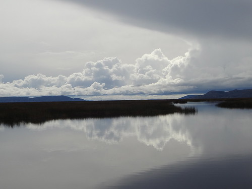
12,500 ft (3810 m) above sea level, straddling Peru and Bolivia, is Lake Titicaca - the highest navigable lake in the world and the source of most giggling among young Geography students*.

About 60% of the lake is in Peru, 40% in Bolivia. Which, my Peruvian guide told me, spawned the phrase "Peru is titi, Bolivia is caca" (cue the giggling again).

DSC02723
Lake Titicaca
From Puno, Peru, you can grab a boat tour to the Uros Islands, made from the tortora reeds growing in the lake. The original Uros tribe built the floating islands to escape from their enemies, but now, the two thousand people living there welcome outsiders, specifically tourists.

DSC02679
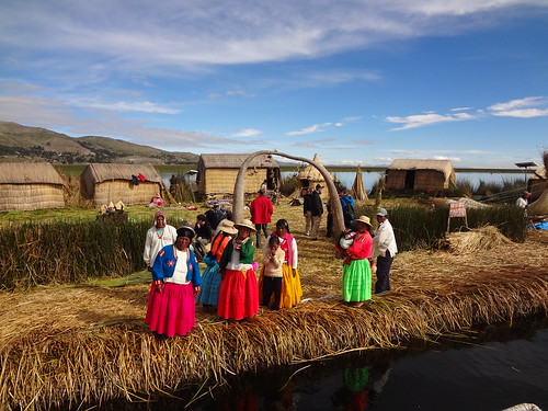
Uros floating islands

There are 60 different floating islands, each with separate communities all wearing traditional clothing and speaking Aymaran. The islands need constant maintenance, with fresh reeds on the ground, otherwise they rot and sink. Walking on the layers and layers of reeds that constitute the islands gives new meaning to the phrase "a spring in your step" - it is quite impressive that the smaller Uros children, who almost bounce off the floor, don't bounce into the lake.

DSC02715
floating island community
The islands aren't very far from Puno, only about 30 minutes by boat. But they still have their own schools, and hospitals and at least three different religious buildings - Catholic, 7th Day Adventist, and Mormon. The islanders often have their own speedboats to get them from place to place, but for the tourists, they break out wonderful boats made from the same tortora reeds as their houses and their islands. For 10 soles, the islanders will row you slowly around the neighborhood - definitely one of the best ways to experience this community.

DSC02709
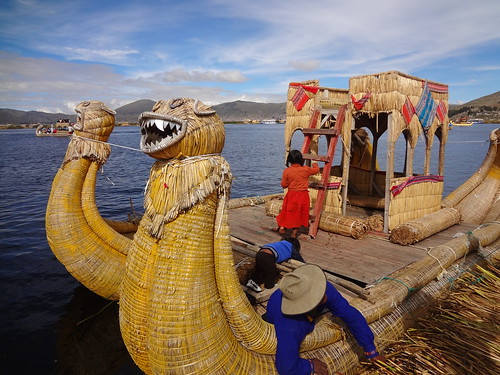
Uros boat made from tortora reeds
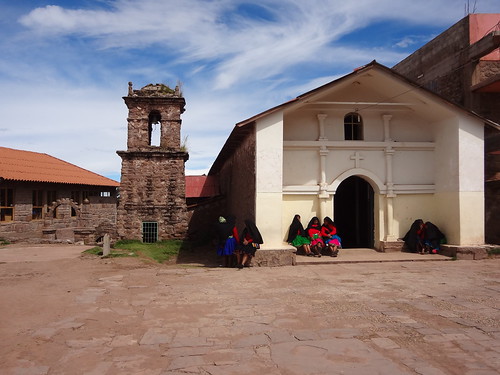
From the Uros islands, it takes two hours by boat to reach one of the biggest islands on the Peruvian side of the lake - Isla Taquile. It is ludicrously bucolic, no cars, no motorized vehicles of any kind, just sheep and cows and farmers. Most of the island is terraced for agriculture, but at the very top, around 13,000 feet or 4,000 meters, they have a village with several shops, a couple of restaurants, a church and a town hall.

DSC02768
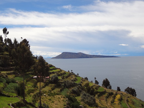
looking out from Taquile
There are six different farming communities on the island, all separated by a stone arch. Every three years, three of the communities will let their fields lay fallow and help the other farmers for free. Then after three years, they switch. Communism!

DSC02758
main village of Taquile
The people wear traditional spanish peasant dress, the women in layers upon layers of skirts with black headdresses, and the men with black trousers, woven belts and different colored bobble hats that delineate their marital status - red for married, white and red for single.
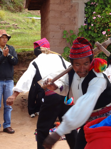
DSC02738
Taquile men
Taquilenos all speak Quechuan, because apparently the Incans sent a bunch of Quechuas to Lake Titicaca as part of their colonization technique.

But almost everywhere else on Lake Titicaca, the population is Aymara, including on the most famous island, the Isla del Sol in Bolivia.
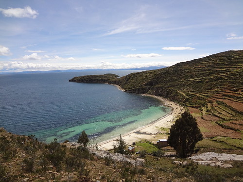
DSC02815
Isla del Sol
Incan legend says that this was the birthplace of the first Inca and the sun god. But the guides are absolutely adamant that what you see here sprang from the Tiwanaku empire, which existed before the Incans.
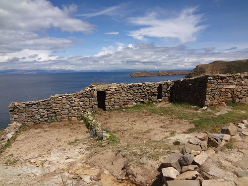
DSC02827
Chinkana ruins
Some say that the lake itself is named after this island, that "Titicaca" is a variation of "Titikala", the sacred rock on Isla del Sol. "Titicaca" apparently means "head of the puma", and either the rock or the lake itself is said to look like a puma. Though how pumas, which could never have survived on Isla del Sol (too small, no prey animals) became important enough in island symbolism to represent the whole lake isn't clear to me.
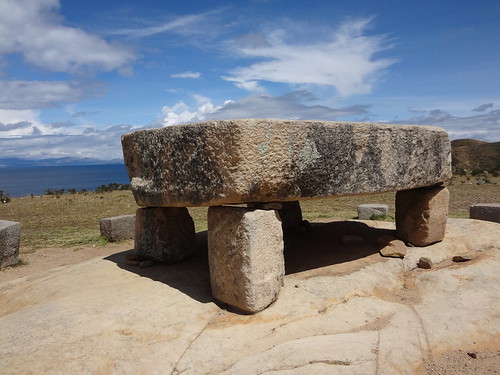
DSC02824
Mesa de Sacrificio
On the north of the island, there are several ruins aside from the sacred rock, including a sacrificial table and the Chinkana laberinto. But lest you forget that Isla del Sol is primarily an agricultural community with tourism as a sideline, there are plenty of furry reminders nibbling around the archaeological sites.
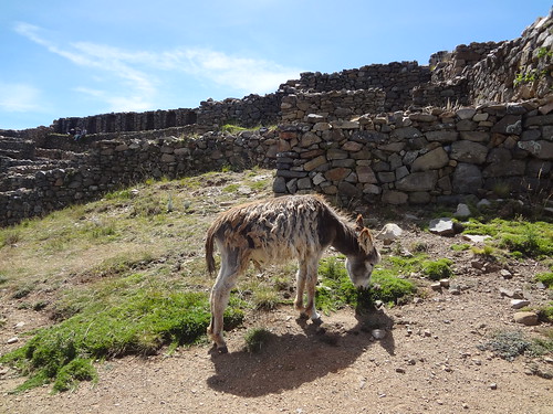
DSC02835
burro de las ruinas
Even though the sun was appropriately shining the whole time I was on Isla del Sol, and most of the time that I was on the rest of Lake Titicaca, it is still REALLY high up, and therefore pretty damn cold. I was wearing three layers, but most of my (smarter) fellow boat passengers were wearing scarves and gloves and antarctic-worthy jackets. I, and my chilblains, highly recommend the latter.
* purely speculative data based on author's own childhood

Monday, April 16, 2012

Raptor & Verse

After Cusco, where I must have been solicited at least thirty times a day to buy a massage, or art work, or a tour, or a shoe shine (for my sneakers), Arequipa was blissfully hassle-free. 

DSC02461
Arequipa (with Chachani volcano in the back)

The city is beautiful, surrounded by volcanoes, with dozens of picture-perfect churches made from the white volcanic rock Sillar. But unlike Cusco, you don't have to pay to go into most of the religious buildings and you can take photos inside.

DSC02450
Catedral, free admission!

That being said, one of the places I DID pay to go into, and it was totally worth the $12 or so, was the Santa Catalina monastery/convent.

DSC02462
Santa Catalina Monastery

It is a city within the city, with its own streets and parks and cemetery and laundry, everything the Dominican nuns needed to stay separate from the secular masses for over three hundred years. They only opened up to the public forty years ago, so the convent is a fascinating time capsule of different architecture, art, and religious techniques.

DSC02492
street in Santa Catalina Monastery

In the area around Arequipa, you can find stunning scenery, including the third deepest canyon in the world, the Colca canyon.

DSC02600
start of Colca Canyon

The canyon starts forming in the picturesque Colca valley, where you can still see working agricultural terraces dating back to pre-Incan times.

DSC02587
Colca Valley

Colca canyon is also home to a large population of endangered Andean condors, but it was too cloudy to see them at the official lookout when I was there this week.

DSC02608
Andean Condor

Fortunately, the magnificent raptors also like to ride the thermals in the valley, where we could actually see them!


Andean Condors from Tina Cone on Vimeo.

Friday, April 13, 2012

Machu Picchu


DSC02324

I had big expectations for Machu Picchu. HUGE expectations. Highly unrealistic expectations.
Or so I thought.
From the moment I set eyes on this citadel in the sky, I was enthralled and verklempt.
Watching as the clouds obscured, then revealed, then concealed, then illuminated the beautiful Incan buildings, perfectly in symmetry with the stunning scenery high up in the Peruvian cloud forest.
Photos, video, words simply don't do it justice.
It was worth all the hassle and expense of getting there. Worth the $110 for the train tickets, worth the $25 in bus tickets, worth the $70 admission, worth the hour-plus queue for a ticket, worth the $65 sleepless night in Agua Calientes so I could get to the site at dawn, worth the rain that arrived every time a cloud rolled in, worth the jostling of hundreds of tourists.
It was worth every single bit.
The only downside for me, was the absence of my dear friend Eelin, who would have been here with me had not an emergency kept her in New York.
On the upside? I get to come back here and see it all over again with her.

DSC02370

DSC02371

DSC02420

DSC02409


DSC02326

Wednesday, April 11, 2012

Ruin Nation

While most people are here for one ruin only, the big one, Machu Picchu, there are actually dozens of Incan ruins scattered around the Sacred Valley, including one that's just a short, gasping walk up from Cusco.

DSC02052
looking down at Cusco from Saqsaywaman

Saqsaywaman - literally pronounced "sexy woman" - provided much of the stone for the Spaniards when they built their own homes and churches so only about 20% of the structure is left.
But what a 20%.

DSC02046
Saqsaywaman

I didn't hire a guide (the entrance fee of about $25 had left me feeling a little sticker-shocked), but there was clear evidence of the outstanding craftsmanship of the Incan stonemasons in the terraces and stairways.

DSC02035
stairway at Saqsaywaman

Most seem to agree that Saqsaywaman was an Incan fortress, and some writers speculate that it was built to represent the head of a puma, with the city of Cusco shaped for its body. Nowadays, you can't see the "head" if you are standing in the "body", but you CAN see the nearby statue of Jesus, bright white and illuminated.

DSC02044
Saqsaywaman, with white Jesus on the hill on the left

Having honed my huffing and scrabbling hiking technique on Saqsaywaman, I headed to Ollantaytambo, a tiny town literally dominated by the Incan ruins towering above it.

DSC02084
view from the top of Ollantaytambo

Looking at, and climbing up, the huge terraces, it was easy to understand how the Incans had won a rare and short-lived victory against the Spanish conquistadors at this site.

DSC02148
much easier going down than up

Part of the upper walkway was taped off when I got there, but fortunately one of the guards, Walter, opened it up for me so I could fully appreciate the sheer size of the terraces. (That red dot in the distance below? That's Walter.)

DSC02100
terraces of Ollantaytambo

Ollantaytambo also happens to be the town where you need to get the train to Agua Calientes (which is trying to rebrand itself as Machu Picchu Pueblo). So after a very satisfying couple of hours wandering around the ruins, it was all aboard to head ever closer to the most famous Incan ruin of them all.

DSC02190
PeruRail train to Agua Calientes

Saturday, April 7, 2012

Cuzco, Cusco, Qosq'o

DSC01957
Plaza de Armas

This city, founded by the first Inca, Manco Capac, was the capital of the Incan empire until the Spaniards came along just under five hundred years ago. It stretches out across the Huatanay valley, and contains one of the most holy sites of the Incas, Qorikancha or temple of the sun. Of course, the Spaniards built their OWN religious edifice right on top of it, so now the only way you can see what remains of the old temple is by visiting the Santo Domingo monastery. The conquistadors stripped the building of gold, but you can still see the impressive Incan stonework, for example, in the grey circular wall pictured below.

DSC01919
Qorikancha with Santo Domingo sitting on top

While the colonial influence is tangible, much of this city hadn't changed for thousands of years. Until Hiram Bingham came across Machu Picchu and told the world. Now, it's tourist central, with plenty of Incan references everywhere (not to mention touts offering you a massage or a painting or a tour every three steps).

DSC01955
fountain in the Plaza de Armas

But despite the hordes of fellow tourists, this city is pretty magical. Just an hour after my arrival, I happened to glance up a nearby street to see a Quechan woman leading a llama up the steps. That's something you don't see every day, even in New York.

DSC01913
just a lady and her llama

I also happened to arrive here during Easter week, Semana Santa. And while I missed the big parade on the Monday before Easter, which features the Lord of Earthquakes, I did catch the Good Friday procession as it left La Merced church. Here's a little footage from that:


Good Friday Procession from Tina Cone on Vimeo.

Even though the city is in a valley, it's still REALLY high in the mountains - 11,000 plus feet. So the altitude is palpable. Fortunately I've been keeping myself hydrated with a combination of the local Cusquena brew and coca tea. Just what the doctor recommends, right?

DSC01924
breakfast, lunch and dinner of champions

Tuesday, April 3, 2012

Three Day Dash

I'm on such short schedule that I unfortunately found myself with VERY little time to see Ecuador. Only about a week. So I had to move quickly after visiting Quito.

First stop, Otavalo for the Saturday morning market. Trading has been happening here since before the Incan Empire, and is a great place to shop for ponchos and blankets made by the indigenous Otavelenos.

DSC01795
Plaza de Ponchos, Otavalo
Of course, I couldn't really BUY anything - no space in the backpack - but it was still impressive. Even for someone as shopping-averse as me.

DSC01796
Saturday morning market, Otavalo
I also got the chance to visit Cotacachi, a gorgeous town known for its leatherwork. It's only about a 30 minute bus ride away from Otavalo and well worth the trip.

DSC01793
Cotacachi
After that, I headed south, to the snow-covered and still active Cotopaxi volcano.

DSC01868
Summit of Cotopaxi volcano
The national park and the area surrounding it are simply stunning, it is literally a cradle of volcanoes.

DSC01805
view from the hostel
While you CAN climb Cotopaxi, I'm in absolutely no such shape for such an undertaking (apparently the success rate is only about 30%). So instead, I took a lovely walk around the Laguna de Limpiopunga near the foot of Cotopaxi.

DSC01853
wild horses at the foot of Cotopaxi Volcano
From Cotopaxi, I hopped a bus south to Banos. It's a big tourist town, for locals and gringos alike, despite the potential threat from Volcano Tungurahua. Apparently, the town had to evacuate about ten years ago, and the military and police took over. When people did return, their homes had all been looted, so the next time the government asked them to evacuate, a lot of people refused.

DSC01898
Banos

Unfortunately, it was a bit rainy, so I didn't actually go to the volcanic thermal baths from which the town presumably got its name. But I did rent a jeep and drive (through the pouring rain on mountain roads) to see a waterfall about 17 km out of town.

DSC01890
Pailon del Diablo
The skies had cleared by the time I got to El Pailon del Diablo (the Devil's Cauldron), but it didt matter. I got soaked by the thundering waterfall itself instead!

DSC01886
getting drenched by Pailon del Diablo